
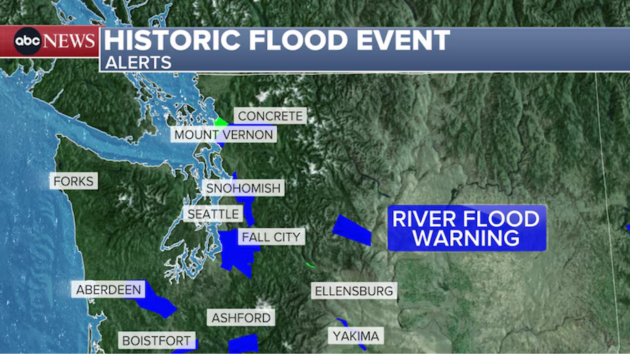
(NEW YORK) — Another atmospheric river is forecast to pound the Pacific Northwest with several inches of rain on Monday and Tuesday just after a short break in the rain.
Most river levels in Washington and Oregon are now beginning to fall and forecast to remain below major flood stage in the next few days.
A break in heavy rain is forecast on Saturday for Washington and Oregon, but rain will be back on Sunday with the heaviest falling Monday and Tuesday.
Some rivers are forecast to rise again on Wednesday due to this next atmospheric river event. There is no end in sight for this pattern — this is a classic La Nina pattern, and this is a La Nina winter.
Some models are forecasting another 5 to 10 inches of rain in the next seven days for the Pacific Northwest.
Eastern arctic blast
Snow and cold alerts are issued for 27 states from Montana to New Jersey and down to Georgia.
A fast-moving storm system is expected to drop several inches of snow on Saturday into the night from the Midwest to the Northeast.
Snow will fall mostly in the Midwest from Iowa to Ohio and Indiana on Saturday, missing Chicago but hitting hard Indianapolis and Cincinnati where a winter storm warning has been issued.
Parts of the Midwest could see up to a half a foot of snow.
Later Saturday, in the early evening, snow and rain will arrive to I-95 corridor.
Rain will change to snow in New York City and Philadelphia late Saturday with heaviest snow falling after midnight and into the early morning hours.
A winter weather advisory has been issued for Washington, D.C., Philadelphia and New York City for 1 to as much as 4 inches of snow.
If New York City and Philadelphia get at least 2 inches of snow, this would be the heaviest snow this early in the season since 2018.
Washington D.C. already saw snow this season, and is forecast to get 1 to 3 inches.
The snow is over by mid morning for the East Coast as the bitter cold takes over.
Extreme cold watches and warnings have been issued from the Dakotas all the way to Alabama.
In the Dakotas and Minnesota, the wind chill could drop as low as 45 below zero with actual temperature in the 20s below zero.
Even for Charleston, South Carolina, an extreme cold watch has been issued, where the wind chill could drop to 10 degrees.
Copyright © 2025, ABC Audio. All rights reserved.