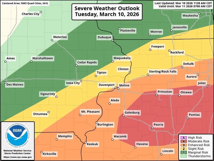
Part of the listening area was elevated to a 4 out of 5 for severe weather tonight , March 10, 2026. The same area is under a tornado watch until 11 PM. The area in red on the map below shows the areas most likely to experience severe weather, including large hail, strong winds, heavy rain, and/or tornadoes. Have a plan in place in the event severe weather hits your home or work.
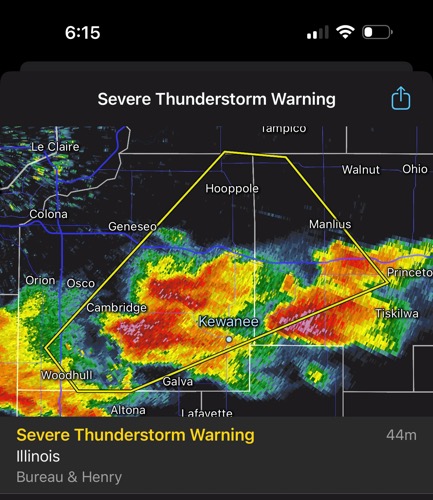
Severe Thunderstorm Warning
National Weather Service Quad Cities IA/IL
608 PM CDT Tue Mar 10 2026
The National Weather Service in the Quad Cities has issued a
* Severe Thunderstorm Warning for… Southeastern Henry County in northwestern Illinois… Northwestern Bureau County in north central Illinois…
* Until 700 PM CDT.
* At 607 PM CDT, a severe thunderstorm was located over Ulah, or near Cambridge, moving northeast at 40 mph.
HAZARD…60 mph wind gusts and half dollar size hail.
SOURCE…Radar indicated.
IMPACT…Hail damage to vehicles is expected. Expect wind damage to roofs, siding, and trees.
* Locations impacted include… Kewanee, Cambridge, Geneseo, Wyanet, Atkinson, Sheffield, Annawan, Woodhull, Andover, Buda, Hooppole, Neponset, Yorktown, Manlius, Mineral, Bishop Hill, New Bedford, Thomas, Henry County Fairgrounds, and German Corner.
This includes the following highways… Interstate 80 in Illinois between mile markers 21 and 50. Interstate 74 in Illinois between mile markers 27 and 31.
NWS 5:50 PM update: Tornadoes will be possible, along with very large hail in areas of southeast Iowa, northeast Missouri, and west central Illinois through 8 PM. Farther north, severe storms with large hail are possible with storms, along with isolated damaging winds. All storms will move east to northeast around 40 MPH.
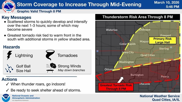
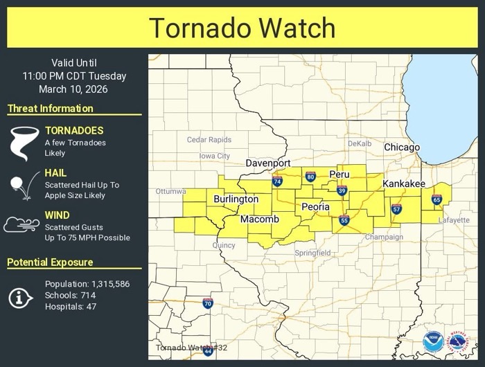
NWS of the Quad Cities 4 PM update: [3/10/26 3:55 pm]: A tornado watch has been issued for areas south and east of the Quad Cities until 11pm this evening. Expect storm coverage to rapidly increase over the next 2-3 hours in the watch area.
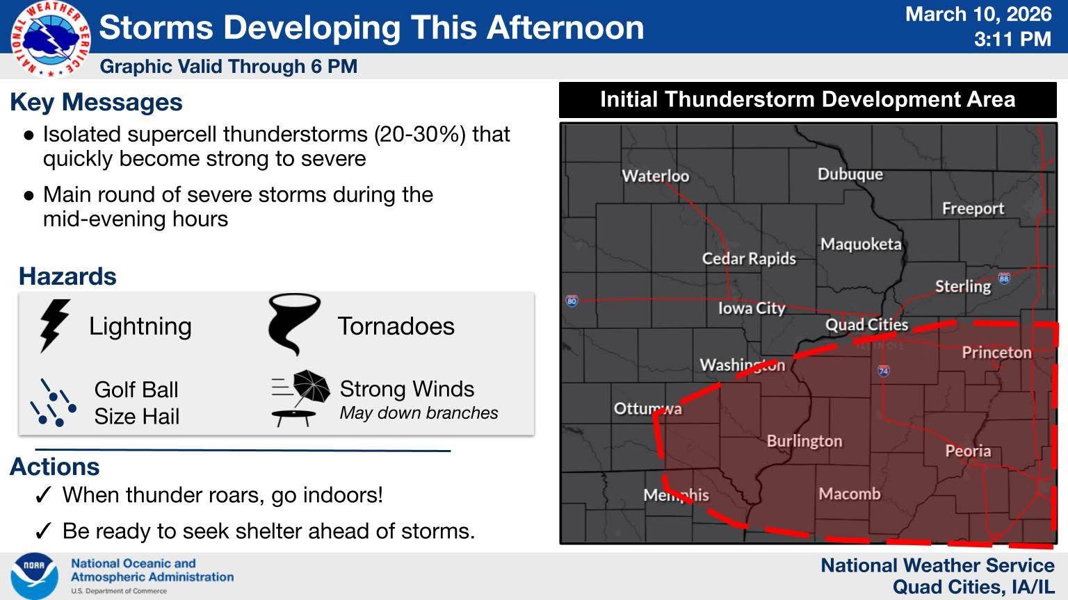
NWS 4 PM: update: Isolated supercell thunderstorms (20-30%) that quickly become strong to severe are expected to develop through late afternoon, mainly over far southeast Iowa and Illinois (Along and south of Interstate 80). These storms will bring the threat for very large hail, damaging winds, and tornadoes. The main round of severe storms during the mid-evening hours which may included areas farther north with a threat for hail, with the tornado threat continuing in Illinois.