• Cold Weather Advisory - Click for Details
    ...COLD WEATHER ADVISORY REMAINS IN EFFECT UNTIL NOON CST SATURDAY...
    Expires: January 24, 2026 @ 12:00pm
    WHAT
    Very cold wind chill values of 15 to 30 below zero.
    WHERE
    Portions of north central, northwest, and west central Illinois, east central, northeast, and southeast Iowa, and northeast Missouri.
    WHEN
    Until noon CST Saturday.
    IMPACTS
    The dangerously cold wind chills as low as 30 below zero could cause frostbite on exposed skin in as little as 30 minutes.
    PRECAUTIONARY/PREPAREDNESS ACTIONS
    Use caution while traveling outside. Wear appropriate clothing, a hat, and gloves.

Loading advertisement…

Severe Thunderstorm Warning for Part of Henry County into Bureau County

SHARE NOW

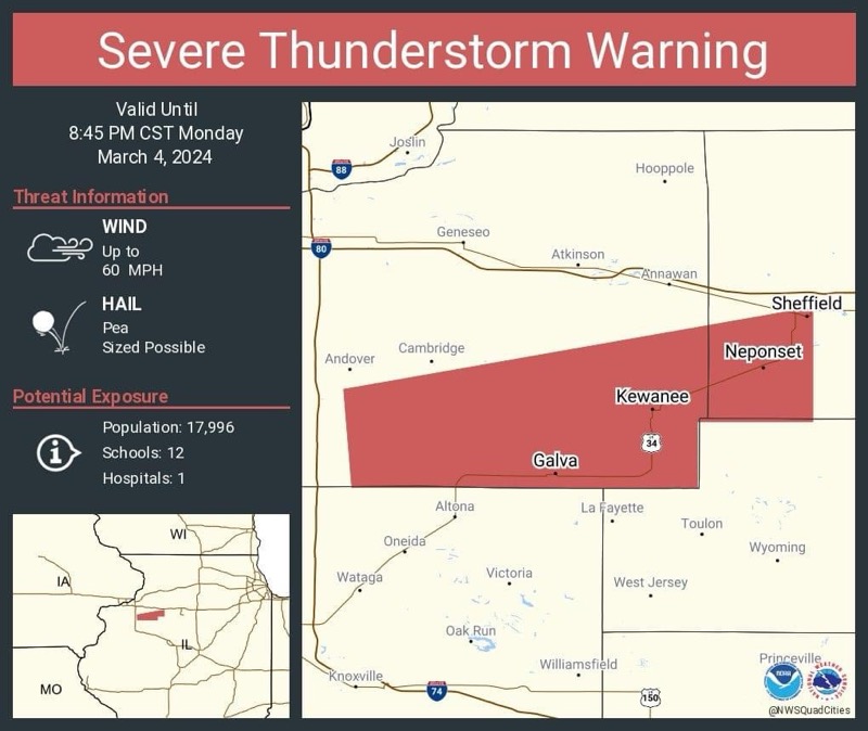
The National Weather Service in the Quad Cities has issued a Severe Thunderstorm Warning until 8:45 PM on March 4, 2024. A severe thunderstorm was located 9 miles South of Cambridge, moving east at 35 mph.  Wind gusts of 60 mph are possible with their storm as well as 3/4 inch size hail. Areas impacted are: Kewanee, Cambridge, Galva, Sheffield, Neponset, Bishop Hill, Nekoma, Kewanee Municipal Airport, Germans Corner, Ulah, and Johnson’s Park.

Submit a Comment