

(CALIFORNIA) — A powerful atmospheric river storm system is expected to bring life-threatening and damaging flooding, wind, snow and waves to California this weekend.
Flood watches will be in effect starting Saturday night through Tuesday in central and southern California. Dangerous and life-threatening flooding is possible with this event, including in urban areas.
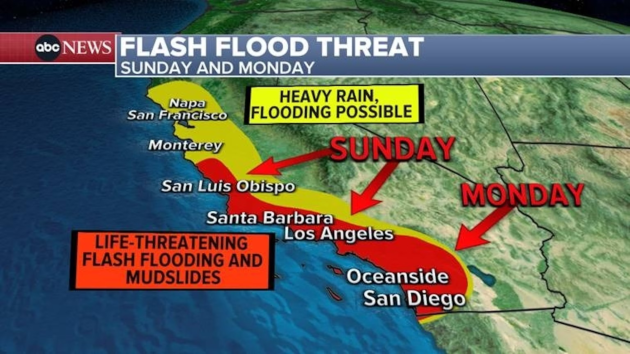
Rainfall totals of 3 to 6 inches will be common, with 6 to 12 inches possible across south and southwest-facing foothills and mountains. The heaviest rain is expected Sunday and Monday, with up to 1 inch per hour possible during the peak. Long durations of heavy rainfall — from three to six hours — are also forecast.
Abundant freeway flooding in high-populated areas is expected. Even the lowest projections for rainfall will be enough to produce damaging flooding, according to the National Weather Service’s Los Angeles office.
Los Angeles Mayor Karen Bass urged residents to stay off the roads on Sunday.
“We’re fortunate that much of the storm will hit Sunday when many people are home anyway,” Bass said during a press briefing late Saturday. “But when in doubt, stay home. Stay informed.”
The city will be fully staffed to prepare to respond to any water-related emergencies and has “bolstered” its air resources in anticipation of the storm, the city’s fire chief, Kristin Crowley, said at the briefing.
There will be the threat of extensive rock and mudslide activity on mountain and canyon roadways, which could cause significant travel delays and road closures.
Evacuation warnings were issued on Friday for parts of Santa Barbara County due to the incoming storm’s “potential to produce flash flooding, debris flows and landslides.” Emergency officials said residents should be ready to leave at a moment’s notice, while people with disabilities and those with large animals were advised to leave.
Damaging winds will also be a big issue. Gusts between 60-80 mph are forecast on Sunday, especially in the mountains off the California coast.
Damaging winds will blow down trees and power lines. Widespread power outages are expected. Travel will be difficult, especially for high-profile vehicles. Extensive wind damage is expected in mountain areas.
A high surf advisory is already in effect, lasting through Monday. Waves could reach 20 feet, peaking Sunday.
There is an increased risk of ocean drowning. Rip currents can pull swimmers and surfers out to sea. Large breaking waves can cause injury, wash people off beaches and rocks and capsize small boats near shore.
Significant damage to roads or structures is not expected, according to the National Weather Service.
Winter storm warnings will also be in effect from Saturday evening to Tuesday in the Sierra Nevada mountain range, where very heavy snow is expected.
Total snow accumulations of 2 to 4 feet are expected, with up to 5 to 6 feet at the higher mountain peaks.
Timing the storm
Rain is forecast to move in Saturday evening and continue to intensify and spread through the night.
By Sunday morning, heavy rain is expected along much of the California coast, with heavy snow in the mountains.
Late Sunday afternoon, as the Grammy Awards are underway in Los Angeles, the heaviest rain from this storm will be centered over Los Angeles and surrounding areas. Flash flooding is likely, including in urban areas, as well as damaging winds. Delays are expected at Los Angeles International Airport.
By Monday morning, the heavy rain is expected to be in the San Diego area, with flash flooding likely. The rain is forecast to continue and get lighter throughout the day.
Copyright © 2024, ABC Audio. All rights reserved.