

(NEW YORK) — This weekend will bring severe storms and a flood risk to the southern U.S., while the Rockies and Western Plains are expected to see heavy snow. Meanwhile, the Northeast will see record warm temperatures.
A very slow-moving storm system will bring heavy rain and storms to the South over the next three days. On Saturday, a flash flood threat looms from east Texas to western Tennessee, including Shreveport, Louisiana, and Memphis, Tennessee. This area could see 1 to 3 inches of rain, with locally higher amounts up to 4 inches.
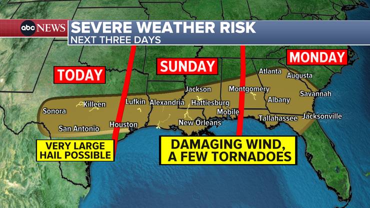
Severe storms are also possible across the South through Monday.
Today’s storm threat could bring large hail to San Antonio, Texas. An isolated tornado and damaging wind is also possible in Texas, with all threats beginning Saturday evening and continuing overnight when the storms begin marching east.
On Sunday, the severe threat reaches from Houston, Texas, to Mobile, Alabama, and includes New Orleans, Louisiana. Damaging wind and tornadoes will be possible with these storms. The greatest threat is after dark and overnight.
On Monday, the storm pattern will hit the Southeast, centering around Georgia and Northern Florida and its panhandle. Damaging wind and tornadoes are the main threats here.
Heavy snow
On the backside of this storm system, there is quite a bit of snow expected for the Rockies and western Plains over the weekend. Snow is already falling from New Mexico to Wyoming.
From Denver to Greeley, Colorado, anywhere from 1-8 inches of snow have fallen. More snow is expected on Saturday, leading to storm totals between 2 to 12 inches depending on the location. Denver is expecting 2 to 6 inches.
Winter Storm Warnings are out for New Mexico, including Santa Fe. Lower elevations are expecting 3 to 8 inches with the mountains seeing up to 16 inches of snow this weekend.
Winter Storm Watches are set for western Oklahoma, which could see 3 to 5 inches of wet snow between Saturday night and Sunday evening. Winds may gust up to 40 mph, reducing visibility. In the Texas panhandle, between 3 and 10 inches of snow is expected between Saturday night and Sunday night.
One more day of record warmth
On Friday, Chicago tied a record daily high of 56 degrees; Grand Rapids, Michigan, tied at 55 degrees; Detroit, Michigan, tied at 64 degrees; and Syracuse, New York broke its previous daily record reaching 63 degrees, well above its 59 degree record from 1925.
Saturday is the last day with possible record highs. The extremely warm February weather will be in the Northeast. Burlington, Vermont, could break its old daily record of 46 degrees by reaching the 50s. Albany, New York, is also among the likely records on Saturday, reaching the upper 50s. The storm system in the South will head to the Northeast on Tuesday with snow possible.
Copyright © 2024, ABC Audio. All rights reserved.