
(NEW YORK) — More than 100 million Americans are under winter alerts Friday as a storm hits the Mid-Atlantic and Northeast and another brutal surge of Arctic air pushes into the South.
Over 1,000 flights have been canceled Friday, with Ronald Reagan Washington National Airport in the Washington, D.C., area and LaGuardia Airport in New York City the hardest hit.
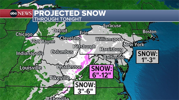
The snow forecast
Snow fell from Indiana to Delaware on Friday, causing dangerous commutes in Cincinnati, Pittsburgh, Washington, D.C., Baltimore and Philadelphia.
Most areas are forecast to see 2 to 5 inches.
New York City may get 1 to 2 inches of snow — the second day this week with more than 1 inch of snow following New York City’s snow drought of more than 700 days.
Philadelphia has declared a snow emergency and the city’s school district has closed schools for Friday. Mayor Cherelle Parker warned Thursday night that the storm is “an all-hands-on-deck moment.”
Baltimore City Public Schools and Pittsburgh’s public schools also closed their doors on Friday.
In Nashville, schools have been shut down the entire week in the wake of the snowfall that wreaked havoc on roads.
In snow-covered Cincinnati, the police department is asking drivers not to call 911 for car crashes unless someone is hurt.
The snow will end by Friday night, leaving bitterly cold temperatures across much of the Northeast.
Brutal cold
Another major Arctic blast is bringing dangerously low temperatures to the Plains, the Midwest and the South this weekend.
The wind chill — what temperature it feels like — is forecast on Sunday to plunge to minus 17 degrees in Chicago, minus 10 degrees in Kansas City, 2 degrees in Nashville and 8 degrees in Philadelphia.
Freeze alerts are in effect for cities as far south as New Orleans, Jacksonville, Florida, and Corpus Christi, Texas.
ABC News’ Ahmad Hemingway contributed to this report.
Copyright © 2024, ABC Audio. All rights reserved.