

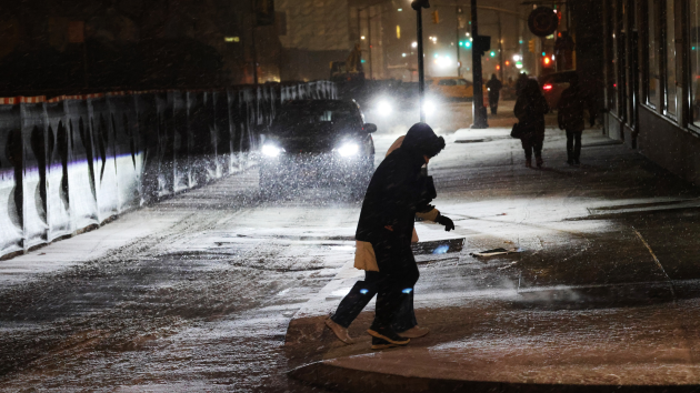
(NEW YORK) — Heavy snow fell from southern Connecticut through the Hudson Valley and into parts of upstate New York on Friday as most of Long Island saw anywhere from 2 to 6 inches of snow.
Meanwhile, the New York City area accumulated just short of 3 inches of snow as difficult travel conditions are expected through Saturday morning while crews work to clean up this wintry mess.
The winter storm is beginning to wrap up, but some lingering light snow and wintry mix will stick around through Saturday along the I-95 corridor as an additional inch of snow and a light glaze of ice will be possible across the region.
Meanwhile, low temperatures across the Northeast from Washington, D.C. and Pittsburgh to the North and East will be near or below freezing on Saturday night, allowing for refreezing of any slush or snow that’s still on the ground.
Another system will move through the region late Sunday into Monday but will be mostly rain, though some wintry mix will be possible into higher elevations.
This weekend, a storm system will move from across the country and bring more snow to the inner mountain West on Saturday and eventually rain to the east on Sunday.
On Saturday, the Rocky Mountains will get snow from Idaho and Montana through Wyoming and Colorado. On Sunday, some snow may linger in the Colorado Rockies and into northern New Mexico.
Most of these mountain areas will see up to a foot of snow, but some areas could see up to 18 inches.
On Sunday, rain will pick up across the Midwest from Kansas and Missouri through Ohio and Pennsylvania while scattered thunderstorms are possible from Arkansas up to Ohio, with some possibly strong enough to bring gusty winds and maybe an isolated tornado.
This system is expected to continue to move through the East late Sunday through Monday, bringing rain for most and freezing rain for some in northern New England.
Next week is expected to start off wet for the East on Monday and will bring mostly rain to the East Coast, with some snow and wintry mix possible for the Great Lakes.
Most of the country should see dry and quiet weather leading up to New Year’s Eve, with the West seasonably warm and the East seasonably cooler.
After New Year’s, a new weather pattern will stick around for the start of 2026 as warmer temperatures should stick around for most of the West and reach down into parts of the South.
Meanwhile, the Upper Midwest and Northeast will be on the cooler side with an active pattern of quick-moving systems possible.
Copyright © 2025, ABC Audio. All rights reserved.