

(The Center Square) – The USDA has just released updated Plant Hardiness Zone Maps for the nation.
The new maps have moved Illinois planting zones to a higher number of designations in response to warmer winters and other climate changes.
Dr. Trent Ford, the Illinois State Climatologist at the University of Illinois, said farmers have been reporting changing conditions since the last hardiness zone maps were released in 2012.
“Here in Illinois, we have gotten warmer and wetter,” Ford said.
Hardiness zones are only one metric in a complex picture, Ford emphasized. The number of designations is determined by the coldest winter temperatures that are recorded every year.
“The very lowest temperatures, the most extreme cold conditions, have warmed at a faster rate than milder conditions,” Ford said.
Illinois is experiencing far fewer instances of extreme temperatures than the state has been used to in the past 30 to 100 years, Ford said. When bitter cold hits, it does not last as long as it used to.
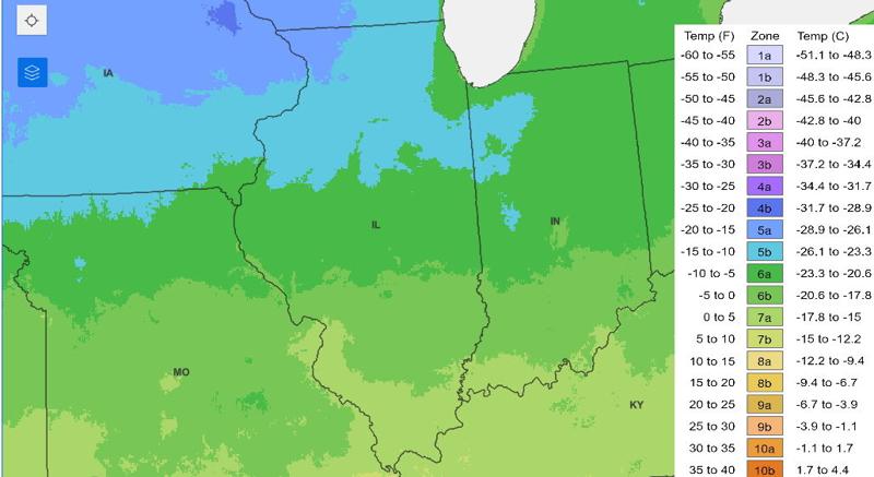
“As a result, most of Illinois’ hardiness conditions have shifted north,” Ford said. Springfield and Peoria are two examples.
In 2012, the last time the U.S. hardiness zone maps were updated, Springfield was on the cusp of a “5b” or “6a” designation. In the new 2023 maps, Springfield is squarely a “6b.” Peoria was a “5b” on the 2012 map. Peoria is now on the “6a/6b line,” Ford said.
A first for Illinois on the 2023 hardiness zone maps: a “7b” designation for a small area in Pulaski County in far southern Illinois. That region jumped two positions on the new maps.
“It was a little bit surprising to see how far that shifted,” Ford said.
Growing conditions in that slice of Pulaski County are hotter and wetter than in the rest of Illinois, comparable to growing conditions in western Tennessee and below that, Ford said.
“This is one signal, not the only one, of our changing winter climate here,” he said.
The coldest growing zone in Illinois is in the top northwest portion of the state, which is designated “5a.” Most of northern Illinois is designated “5b.” Moderating conditions from Lake Michigan and urban sprawl put the majority of Chicagoland in zone “6a.” Most of central Illinois north of Interstate 70 is also designated “6a.” Areas between I-70 and I-64 are designated zone “6b.” Most of southern Illinois falls in zone “7a.”